calgary :a place to visit
by aravind
(trivandrum,kerala,india)


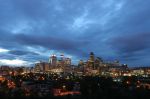
View of downtown Calgary
I did no get a chance to visit calgary but i crave hard to visit this magnificent place.
Calgary is located at the transition zone between the Canadian Rockies foothills and the Canadian Prairies, and is relatively hilly as a result. Calgary's elevation is approximately 1,048 m (3,440 ft) above sea level downtown, and 1,083 m (3,550 ft) at the airport. The city proper covers a land area of 726.5 km2 (280.5 sq mi) (as of 2006)25 and as such exceeds the land area of the City of Toronto.
The site truly inspire me to visit calgary.
There are two major rivers that run through the city. The Bow River is the largest and flows from the west to the south. The Elbow River flows northwards from the south until it converges with the Bow River near downtown. Since the climate of the region is generally dry, dense vegetation occurs naturally only in the river valleys, on some north-facing slopes, and within Fish Creek Provincial Park.
The city is large in physical area, consisting of an inner city surrounded by various communities of decreasing density. Unlike most cities with a sizable metropolitan area, most of Calgary's suburbs are incorporated into the city proper, with the notable exceptions of the city of Airdrie to the north, Cochrane to the northwest, Strathmore to the east, and the Springbank district to the west. Though it is not technically within Calgary's metropolitan area, the town of Okotoks is only a short distance to the south and is considered a suburb as well. The Calgary Economic Region includes slightly more area than the CMA and has a population of 1,146,900.
The city of Calgary proper is immediately surrounded by two municipal districts, Rocky View No. 44 to the north, west and east; and Foothills No. 31 to the south.
Calgary's neighbourhoods
The Calgary neighbourhood of Signal Hill, with the Rocky Mountains seen in the background.
The downtown region of the city consists of five neighbourhoods: Eau Claire (including the Festival District), the Downtown West End, the Downtown Commercial Core, Chinatown, and the Downtown East Village (also part of the Rivers District). The commercial core is itself divided into a number of districts including the Stephen Avenue Retail Core, the Entertainment District, the Arts District and the Government District. Distinct from downtown and south of 9th Avenue is Calgary's densest neighbourhood, the Beltline. The area includes a number of communities such as Connaught, Victoria Crossing and a portion of the Rivers District. The Beltline is the focus of major planning and rejuvenation initiatives on the part of the municipal government26 to increase the density and liveliness of Calgary's centre.
Adjacent to, or directly radiating from the downtown are the first of the inner-city communities. These include Crescent Heights, Hounsfield Heights/Briar Hill, Hillhurst/Sunnyside (including Kensington BRZ), Bridgeland, Renfrew, Mount Royal, Mission, Ramsay and Inglewood and Albert Park/Radisson Heights directly to the east. The inner city is, in turn, surrounded by relatively dense and established neighbourhoods such as Rosedale and Mount Pleasant to the north; Bowness, Parkdale and Glendale to the west; Park Hill, South Calgary (including Marda Loop), Bankview, Altadore, Chapparal, and Killarney to the south; and Forest Lawn/International Avenue to the east. Lying beyond these, and usually separated from one another by highways, are the suburban communities. In all, there are over 180 distinct neighbourhoods within the city limits.27
Several of Calgary's neighbourhoods were initially separate towns that were annexed by the city as it grew. These include Bowness, Montgomery, Forest Lawn, Midnapore, Rosedale and, most recently in 2007, Shepard.
Barry's Response - I don't know where you got this from, Aravind. Probably Wikipedia or something. This factual information sums up the physical structure of the city quite well. Nice photo too.
Comments for calgary :a place to visit
|
||
|
||
|
||
|
||
|
||
|
||
Recent Articles
-
Calgary Canada Weather - You shall Never Find a Dull Moment
Mar 09, 25 01:59 PM
 Forecasts for Calgary Canada weather. Compare forecasts from Environment Canada, the Weather Network and others.
 -
Auto Trader Calgary | Do YOU Need the Perfect Car?
Mar 02, 25 09:49 PM
 Life in Calgary. Find the deal you need with "Auto Trader Calgary" or by visiting the lots on this page.
 -
oneway streets downtown
Feb 24, 25 12:20 AM
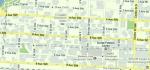 Hard to find a map of downtown Calgary that shows the oneway streets Barry's Response - Here is a crude reproduction of an olde-style Google map for the